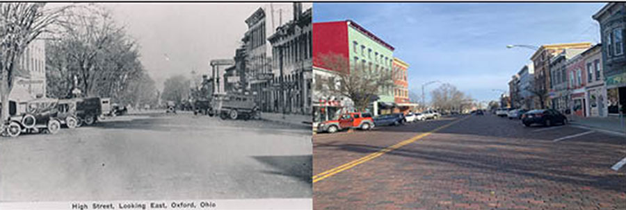
This was the view looking east down High Street in the early 1900s. Today the cars are newer and there are yellow lines down the middle of High Street, but the diagonal parking spots remain. Left photo provided by the Smith Library of Regional History and right photo by Mallory Hackett
Oxford hasn’t always looked the way it does today. Before the paved roads, the restaurant chains and the bars, it was a patch of mostly uninhabited woods. The village was laid out in 1810, about a year after Miami University was chartered. By 1830, Oxford claimed about 700 residents, according to the city’s website.
Oxford didn’t become an actual city until 1971. Over the years, much has changed, but much has stayed the same.
W. Park Place in the early 1900s. Note the classic gas pumps in front of the Ford service station. Offices have replaced the service station and the pumps are long gone, but the windows and roofline remain the same. Left photo provided by the Smith Library of Regional History. Right photo by Mallory Hackett
To get a look at how Oxford appears today compared to its earlier years, the Oxford Observer has created a set of comparable photos of Uptown. The older images are from the Smith Library of Regional History. The comparisons show how the town has aged and changed, but if you look closely, you can still see the face of old Oxford in the shops and streetscapes that we know today.
Adams’ Drug Store occupied a prominent High Street corner in 1915. The front awning has disappeared, but the distinctive stepped brick end wall on the building continues to stand out on the McCullough block. Left photo by Frank R. Snyder and provided by the Smith Library of Regional History. Right photo by Mallory Hackett
If you would like a closer inspection of what the city once looked like, the Smith Library has created a self-guided walking tour of Oxford.
E. High St. in the early 1960s. The drug store is gone and the men’s wear store is the site of The U Shop in 2020. Left photo by George R. Hoxie and provided by the Smith Library of Regional History. Right photo by Mallory Hackett
The Bee Hive Grocery occupied 29 W. High St. in the early 1900s. Today the grocery has gone, replaced by Graeter’s Ice Cream. Note the distinctive arched windows on the second floor. Left photo provided by the Smith Library of Regional History. Right photo by Mallory Hackett
The Uptown Parks in the early 1900s. There are fewer trees today, but the cannon still guards the parks. Left photo by Frank R. Snyder and provided by the Smith Library of Regional History. Right photo by Mallory Hackett
In the 1940s, there was a bank with a clock on the corner at 20 W. High Street, and a dentist practiced on the second floor. Today the building still houses a bank. The clock and the dentist’s sign are gone, but the fire escape remains. Left photo provided by the Smith Library of Regional History. Right photo by Mallory Hackett
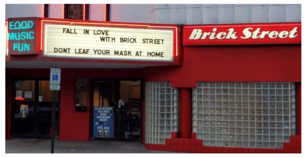
In 1941, the marquee of the Miami Western Theater advertised a variety of shows. Today the theater is gone and the marquee is far more modest, but the Brick Street bar is one of Oxford’s most popular spots for college students. Left photo by the Recensio and provided by the Smith Library of Regional History. Right photo by Mallory Hackett
The old post office was on the corner of W. High Street and College Avenue. The post office has moved, but today the building is the city courthouse and meeting site for the mayor and city council. Left photo by Frank R. Snyder and provided by the Smith Library of Regional History. Right photo by Mallory Hackett